Oberwald
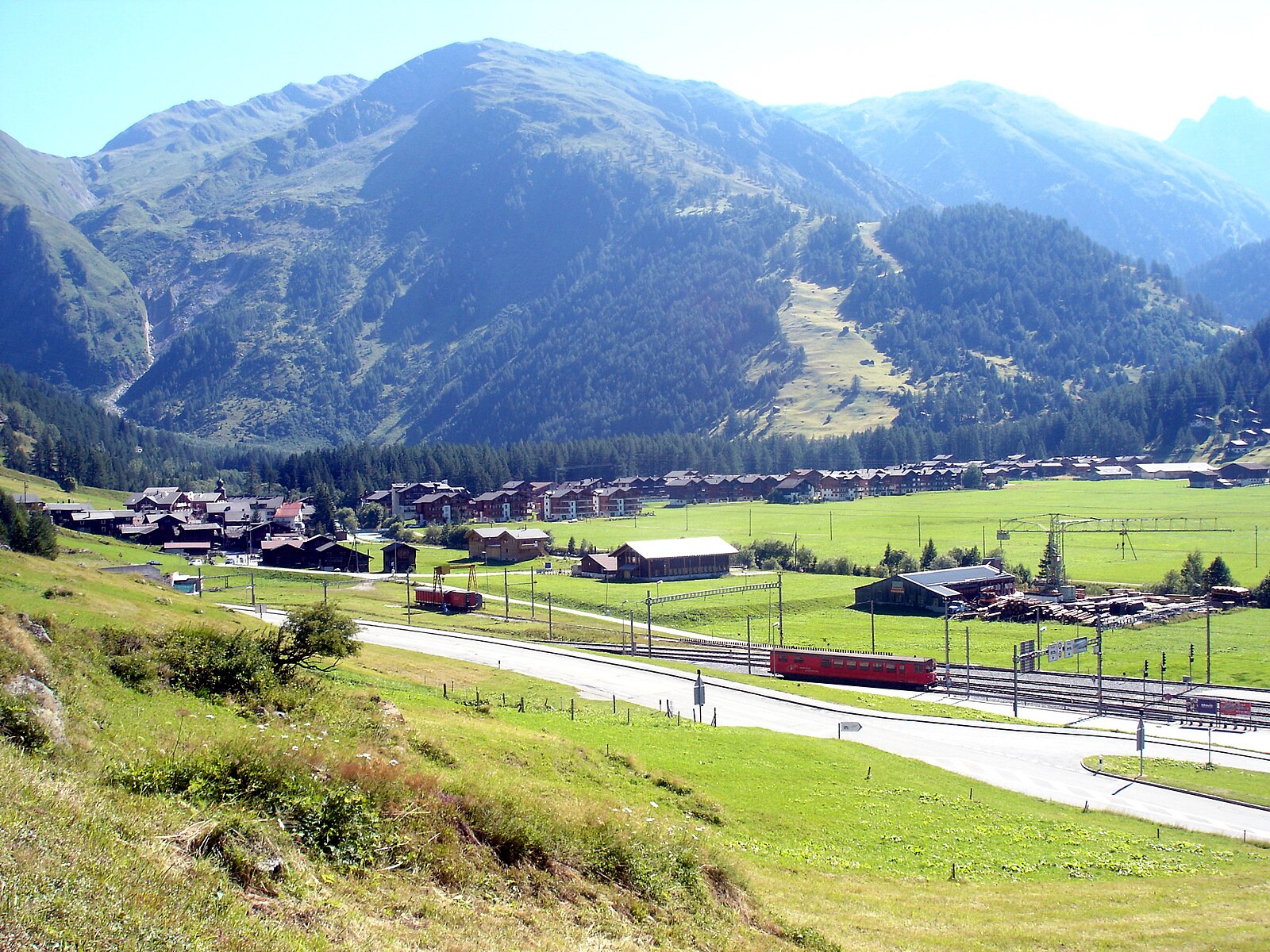
About Oberwald
A serene gateway to the Furka Pass, where cross-country trails wind through a quiet valley defined by tradition and deep winter snow.
Highlights
- Nordic skiing hub
- Historic timber architecture
- Furka Steam Railway
- Quiet valley escape
Key Facts
- Altitude: 1375m
- Top lift: 1404m
- Ski lifts: 1
- Population: 277
- 4000m+ peaks nearby: 3
- Lakes nearby: 31
- MTB trails: 13.7km
- Mountain huts: 23
Ski Area
この目的地が含まれるシーズンパス
Weather and 10-day forecast for Oberwald
- Today: 8 to 21 °C, partly cloudy, 6 h of sunshine
- Freezing level today: about 4266 m (3960 to 4450 m)
| Day | Min / max | Sky | Precipitation | Sunshine |
|---|---|---|---|---|
| 9月20日(日) | 8 / 21 °C | partly cloudy | dry | 6 h sun |
| 9月21日(月) | 9 / 19 °C | overcast | dry | 3 h sun |
| 9月22日(火) | 11 / 19 °C | clear sky | dry | 12 h sun |
| 9月23日(水) | 10 / 19 °C | clear sky | dry | 12 h sun |
| 9月24日(木) | 10 / 18 °C | clear sky | dry | 10 h sun |
| 9月25日(金) | 11 / 21 °C | overcast | dry | 1 h sun |
| 9月26日(土) | 11 / 21 °C | clear sky | dry | 11 h sun |
| 9月27日(日) | 10 / 18 °C | overcast | dry | 2 h sun |
| 9月28日(月) | 10 / 21 °C | clear sky | dry | 12 h sun |
| 9月29日(火) | 7 / 21 °C | clear sky | dry | 12 h sun |
Things to do in Oberwald
Hikes nearby — Oberwald (20)
20+ curated hiking trails around Oberwald, sourced from OpenStreetMap and enriched with distance, elevation gain and difficulty.
-
9 Seen-Weg
The 9 Seen-Weg departs from the Grimselpass and follows a path with alpine character past the Trützisee before descending to Geschinen. The route runs far above the valley floor, threading through dramatic high-alpine scenery on its way between nine lakes.
-
Oberwald - Gletsch
-
14a-Sentiero dei passi alpini
-
Furka-Höhenweg
フルカ・ヘーエンヴェークは、ウルゼレン谷の上に広がる石だらけの南東斜面をたどり、レアルプとホスペンタル、峠道、そして谷を縫うように走る歴史あるフルカ蒸気鉄道を見下ろす眺望が広がる。途中、小さな高山湖、山の小川、ギザギザの断崖、そしてキキョウの仲間——黄色いキキョウ(*Campanula thy…*)を含む——が点在し、ローヌ氷河とボンド映画『ゴールドフィンガー』で有名になったベル・エポック様式のホテル・ベルヴェデールを望む地形を通り抜ける。
-
Vier-Quellen-Weg
Als Vier-Quellen-Weg wird die Schweizer Wanderroute 49 in der Gotthard-Gruppe bezeichnet. Sie beginnt am Oberalppass und führt in fünf Etappen durch die Kantone Graubünden, Uri, Tessin und Wallis im Uhrzeigersinn zum Furkapass.
-
Oberwald - Grimselpass
-
Zahnstangensafari
-
Triebtenseelücke - Grimselpass
-
Oberwald - Obergesteln
-
Obergesteln - Mällige - Oberwald
-
Gerewasserweg
-
Unterwassern - Furkapass
-
Grimselpass - Gletsch
-
Ladstafel-Ulrichen
-
Triebtenseelücke - Trützisee
-
Grimselpass - Oberaar
-
Grimselpass - Rhonegletscher
-
Räterichsboden - Grimselpass
-
Grimsel/Hospiz - Lauteraarhütte
-
Gletsch - Furkapass
The trail begins in Gletsch, which also serves as the endpoint of the Grimsel Pass road, and the Valais side of the Furka Pass is well developed with multiple spots to stop and admire the Rhône Glacier. Several pullouts along the ascent invite you to linger over the glacier before the route continues toward the pass.
Mountain biking near Oberwald
- Gotthard Bike Nufenen Andermatt
- Gommer Höhenweg
- Winterstrasse
- OberwaldFurkapass
Getting to Oberwald
Door-to-door travel times as used by the MR. ALPS ranking.
- Nearest airport: Lugano Airport (LUG), 73 km away, about 1h47 by road
- Luzern: 1h36 by car, 110 km
- Bern: 1h59 by car, 129 km
- Zürich: 2h06 by car, 147 km
- Biel/Bienne: 2h22 by car, 165 km
- Lausanne: 2h35 by car, 191 km
- Milano: 2h37 by car, 201 km
Where to stay in Oberwald
48 places to stay for a night on 2026-09-25, from 159 EUR per night, median 258 EUR. Prices are direct with hotels and destinations, compared live on the Oberwald page.