Walenstadtberg
实时摄像头
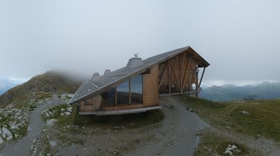
开放缆车: 0%
积雪报告
- 过去24小时: 0 厘米
- 过去72小时: 0 厘米
- 过去7天: 0 厘米
- 过去7天: 山谷 0厘米 · 山腰 0厘米 · 山顶 0厘米
- 本季累计: 0 厘米
About Walenstadtberg
A tranquil sun-trap perched above Lake Walen, known for its sanatorium history and dramatic views of the jagged Churfirsten peaks.
Highlights
- Vertical rock faces
- Therapeutic mountain air
- Panoramic lake vistas
- Mediterranean microclimate
Key Facts
- Altitude: 861m
- Top lift: 930m
- Ski lifts: 1
- Lakes nearby: 19
- MTB trails: 268.8km
- Mountain huts: 22
Ski Area
Weather and 10-day forecast for Walenstadtberg
- Today: 13 to 18 °C, overcast, 3 h of sunshine
- Freezing level today: about 3724 m (3320 to 4130 m)
| Day | Min / max | Sky | Precipitation | Sunshine |
|---|---|---|---|---|
| 9月21日周一 | 13 / 18 °C | overcast | dry | 3 h sun |
| 9月22日周二 | 10 / 17 °C | clear sky | dry | 12 h sun |
| 9月23日周三 | 11 / 18 °C | clear sky | dry | 12 h sun |
| 9月24日周四 | 11 / 16 °C | clear sky | dry | 8 h sun |
| 9月25日周五 | 9 / 19 °C | clear sky | dry | 12 h sun |
| 9月26日周六 | 16 / 23 °C | clear sky | dry | 12 h sun |
| 9月27日周日 | 17 / 25 °C | overcast | dry | 4 h sun |
| 9月28日周一 | 11 / 23 °C | clear sky | dry | 9 h sun |
| 9月29日周二 | 12 / 23 °C | partly cloudy | dry | 6 h sun |
| 9月30日周三 | 13 / 24 °C | partly cloudy | dry | 6 h sun |
Things to do in Walenstadtberg
Hikes nearby — Walenstadtberg (20)
20+ curated hiking trails around Walenstadtberg, sourced from OpenStreetMap and enriched with distance, elevation gain and difficulty.
-
WALSA-Weg - Etappe 2
-
7-Gipfel-Tour Flumserberg
A point-to-point ridge walk that crosses seven peaks and passes fourteen lakes, with views stretching across the mountain kingdoms of St. Gallen, Graubünden, Glarus, and Central Switzerland. The Churfirsten massif forms a backdrop as the route threads between Maschgenkamm and Tannenbodenalp, with a mountain railway available to ease the climbs.
-
WALSA-Weg - Etappe 3
-
Hochrugg - Bergwald
-
Quinten Seeweg
-
Hochrugg - Tschingla
-
rote Raute
-
Tschingla Chäserugg
-
Hochrugg - Tschingla
-
Unterterzen-Walenstadt
The route climbs from the shores of the Walensee up into a varied mountain world, crossing the Maschgenkamm ridge where the panorama opens on one side to the Spitzmeilen massif and on the other to the jagged Churfirsten and Alviergruppe chains looming above the lake. The trail also takes in the celebrated 7-Gipfel-Tour, one of the region's signature highlights.
-
Schwaldis - Hochrugg
-
Walenstadtberg - Quinten
The trail combines shady forest sections with sweeping views of mountain and lake, descending in a zigzag course through the woods before reaching the shoreline of the Walensee. The picturesque village of Quinten waits at the end of the route as a reward for the effort.
-
Walenstadt - Pluder
-
Quarten - Oberterzen
-
Pluder - Bergheim Vadella
-
Tschingla Sennis
-
Laubegg - Säls
-
Voralp - Niederipass - Höchst - Voralp
-
Bergheim Vadella - Bildbrugg
-
Churfirsten-Weg
Mountain biking near Walenstadtberg
- Walensee Bike
- Churfirsten Panoramabike
- Flumserberg-Panoramabike
- See-Abfahrt Flumserberg
- ex. Lüsis Bike
- Blue Bunny
- Sälsweg
- Alpweg
Getting to Walenstadtberg
Door-to-door travel times as used by the MR. ALPS ranking.
- Nearest airport: Sankt Gallen Altenrhein Airport (ACH), 44 km away, about 1h by road
- Zürich: 1h06 by car, 86 km
- Luzern: 1h25 by car, 109 km
- Basel: 2h03 by car, 169 km
- Biel/Bienne: 2h29 by car, 206 km
- Bern: 2h30 by car, 208 km
- Innsbruck: 2h47 by car, 211 km
Where to stay in Walenstadtberg
180 places to stay for a night on 2026-09-25, from 207 EUR per night, median 345 EUR. Prices are direct with hotels and destinations, compared live on the Walenstadtberg page.