Falera
实时摄像头


开放缆车: 0/29
积雪报告
- 过去24小时: 0 厘米
- 过去72小时: 0 厘米
- 过去7天: 0 厘米
- 过去7天: 山谷 0厘米 · 山腰 0厘米 · 山顶 0厘米
- 本季累计: 9.9 厘米
About Falera
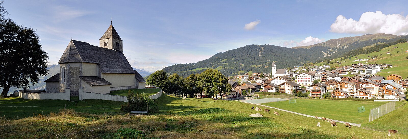
A tranquil sanctuary of Romanesque architecture and megalithic history, offering a refined, quiet alternative to its bustling neighbors.
Highlights
- Prehistoric monolith park
- Romanesque church towers
- Sunny terrace setting
- Quiet luxury vibe
Key Facts
- Altitude: 1220m
- Top lift: 2980m
- Ski pistes: 214km
- Ski lifts: 28
- Population: 635
- Lakes nearby: 9
- MTB trails: 39.2km
- Mountain huts: 9
Ski Area
已包含在以下滑雪通票中
Weather and 10-day forecast for Falera
- Today: 7 to 14 °C, clear sky, 10 h of sunshine
- Freezing level today: about 4130 m (3940 to 4250 m)
| Day | Min / max | Sky | Precipitation | Sunshine |
|---|---|---|---|---|
| 9月20日周日 | 7 / 14 °C | clear sky | dry | 10 h sun |
| 9月21日周一 | 4 / 11 °C | overcast | dry | 3 h sun |
| 9月22日周二 | 3 / 11 °C | clear sky | dry | 8 h sun |
| 9月23日周三 | 4 / 14 °C | clear sky | dry | 12 h sun |
| 9月24日周四 | 1 / 7 °C | snow showers | dry | 1 h sun |
| 9月25日周五 | -1 / 11 °C | clear sky | dry | 12 h sun |
| 9月26日周六 | 4 / 14 °C | clear sky | dry | 12 h sun |
| 9月27日周日 | 7 / 17 °C | clear sky | dry | 12 h sun |
| 9月28日周一 | 5 / 18 °C | clear sky | dry | 12 h sun |
| 9月29日周二 | 5 / 17 °C | clear sky | dry | 12 h sun |
Things to do in Falera
Hikes nearby — Falera (20)
20+ curated hiking trails around Falera, sourced from OpenStreetMap and enriched with distance, elevation gain and difficulty.
-
Via son Giachen
-
Via son Giachen
-
ViaSuworow
-
Senda Sursilvana
The fifth and final segment of the Senda Sursilvana, this point-to-point route runs from Laax to Chur, passing through forests on a 105 km trail that traverses the sunny terraces of the Surselva high above the Vorderrhein.
-
Sardona-Welterbe-Weg Etappe 6
The route crosses the Segnespass at 2,625 metres, where geological phenomena of the UNESCO World Heritage Tectonic Arena Sardona can be examined at close range. Along the way, the boggy moorland of the Segnasboden gives way to thundering waterfalls, deep gorges, boldly engineered bridges, and wild forest.
-
Curnius - Falera
A sunny, easy descent from the Curnius mountain station down to Falera, this winter trail drops nearly 400 metres through the snow-covered landscapes of the Flims Laax Falera region. It is rated simple and runs one-way from mountain station to village.
-
Ladir - Falera
Walking the sunny side of the Surselva valley, this route traces a section of the Camino de Santiago high above the Rhine Valley, linking the mountain village of Falera to the mountain village of Ladir.
-
Ilanz->Station Valendas
-
Panoramaweg Falera-Laax Murschetg
-
Rheinschlucht Wanderung (Auenweg)
The trail winds through the Rheinschlucht — a gorge carved over 10,000 years ago by the Flimser Bergsturz, the largest rockslide in the Alps, when over 25 billion tonnes of rock buried the valley and the Vorderrhein slowly ate through the debris to form sheer white cliff walls plunging to the river below. The surrounding landscape takes in mysterious lakes, jagged ravines, small islands, riparian forests, and a rich birdlife.
-
Crap Sogn Gion - Curnius
-
Valendas-Castrisch
-
Curnius - Laax
-
Siat - Ruschein - Ladir
-
Valendas Dutjer Alp
-
Valendas Riein
-
Ilanz/Glion - Schnaus
-
Jakobsweg Graubünden: Trin Digg Vitg - Falera
-
Senda Sursilvana: Breil/Brigels - Laax Murschetg
-
Jakobsweg Graubünden: Falera - Andiast Vitg
Mountain biking near Falera
- Cuolm Sura
- Never End Trail
- Rene's long way / langer weg
- Durset
- Ruschein Trail
Getting to Falera
Door-to-door travel times as used by the MR. ALPS ranking.
- Nearest airport: Bodensee Airport Friedrichshafen (FDH), 99 km away, about 1h58 by road
- Zürich: 1h48 by car, 145 km
- Luzern: 2h07 by car, 168 km
- Basel: 2h45 by car, 228 km
- Milano: 3h07 by car, 228 km
- Biel/Bienne: 3h11 by car, 266 km
- Innsbruck: 3h11 by car, 243 km
Where to stay in Falera
200 places to stay for a night on 2026-09-25, from 134 EUR per night, median 367 EUR. Prices are direct with hotels and destinations, compared live on the Falera page.