Montriond
ライブカメラ



営業中のリフト: 0/163
積雪情報
- 過去24時間: 0 cm
- 過去72時間: 0 cm
- 過去7日間: 0 cm
- 過去7日間: 山麓 0cm · 中腹 0cm · 山頂 0cm
- シーズン累計: 0 cm
About Montriond
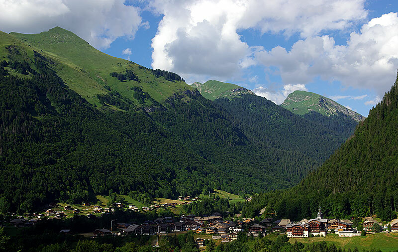
A rustic alternative to Morzine, this sleepy hamlet offers direct access to the vast Portes du Soleil via its emerald-colored lake.
Highlights
- Lakeside winter walks
- Traditional Savoyard chalets
- Gondola forest access
- Low-key atmosphere
Key Facts
- Altitude: 877m
- Population: 956
- Lakes nearby: 22
- MTB trails: 56.9km
- Mountain huts: 14
Ski Area
Les Portes du Soleil – Morzine/Avoriaz/Les Gets/Châtel/Morgins/Champéry
この目的地が含まれるシーズンパス
Weather and 10-day forecast for Montriond
- Today: 5 to 20 °C, clear sky, 12 h of sunshine
- Freezing level today: about 4342 m (4240 to 4450 m)
| Day | Min / max | Sky | Precipitation | Sunshine |
|---|---|---|---|---|
| 9月22日(火) | 5 / 20 °C | clear sky | dry | 12 h sun |
| 9月23日(水) | 6 / 21 °C | clear sky | dry | 12 h sun |
| 9月24日(木) | 9 / 20 °C | overcast | dry | 2 h sun |
| 9月25日(金) | 8 / 19 °C | clear sky | dry | 10 h sun |
| 9月26日(土) | 9 / 21 °C | clear sky | dry | 12 h sun |
| 9月27日(日) | 11 / 22 °C | partly cloudy | dry | 4 h sun |
| 9月28日(月) | 13 / 23 °C | clear sky | dry | 12 h sun |
| 9月29日(火) | 14 / 24 °C | clear sky | dry | 10 h sun |
| 9月30日(水) | 14 / 23 °C | clear sky | dry | 10 h sun |
| 10月1日(木) | 13 / 17 °C | rain showers | dry | 4 h sun |
Things to do in Montriond
Hikes nearby — Montriond (12)
12 curated hiking trails around Montriond, sourced from OpenStreetMap and enriched with distance, elevation gain and difficulty.
-
Lac de Damoz des Moulins
A loop trail straddling the border of the Vallée d'Aulps and the Vallée d'Abondance, it threads through green alpine pastures and past old chalets before arriving at the small Lac de Damoz des Moulins, cradled at the foot of the Pic de la Corne. From the Brion mountain pasture, the route opens onto a sweeping view of Mont Blanc and the Roc d'Enfer.
-
Montée au Roc de Tavaneuse
A sporting ascent to the 2156 m summit of the Roc de Tavaneuse, which commands a view of Mont Blanc. The descent brings you past the Lac de Tavaneuse, described as the most beautiful lake in the Chablais.
-
Au pied du Roc d'Enfer
This loop through the Essert-Romand countryside passes the 1859 Graydon chapel — dedicated to the Immaculate Conception, its porch stones salvaged from Aulps Abbey — before climbing through alpine meadows toward the Col Ratti, a sun-scorched, shadeless pass whose name derives from the French word for "roast." The route unfolds beneath the looming mass of the Roc d'Enfer itself, with views stretching to the Aravis peaks and Mont-Blanc.
-
Tour du Mont Brion
A circuit above Saint-Jean-d'Aulps that crosses two passes through verdant alpine pastures dotted with old shepherd's chalets, with views north to the Cornettes de Bise and south to the Roc d'Enfer — and a small lake, the Lac de Damoz des Moulins, nestled at the foot of the Pic de la Corne.
-
Tour du Mont de Grange
-
Boucle des Mattes
-
Tour du Mont Chauffé
-
40-Chemin des cols alpins
-
Tour des Dents Blanches
-
La Bourgeoise
-
Alpenpässe-Weg: Barme - Morgins
-
Les Bords de Dranse
Mountain biking near Montriond
- Family
- L'Alpage
- Super 8
- La Noire
- Tutti Frutti
- Retour des Nants
- Da trail
- Racine carrée
Getting to Montriond
Door-to-door travel times as used by the MR. ALPS ranking.
- Nearest airport: Annecy Meythet airport (NCY), 55 km away, about 1h14 by road
- Genève: 1h11 by car, 70 km
- Annecy: 1h21 by car, 82 km
- Chambéry: 1h45 by car, 126 km
- Lausanne: 1h47 by car, 104 km
- Bern: 2h23 by car, 161 km
- Grenoble: 2h28 by car, 185 km
Where to stay in Montriond
200 places to stay for a night on 2026-09-25, from 102 EUR per night, median 238 EUR. Prices are direct with hotels and destinations, compared live on the Montriond page.