Wengen
Živá webkamera



Otevřené vleky: 0/49
Sněhová zpráva
- Posledních 24h: 0 cm
- Posledních 72h: 0 cm
- Posledních 7 dní: 0 cm
- Posledních 7 dní: Údolí 0cm · Střední část 0cm · Vrchol 0cm
- Sezónní úhrn: 2.6 cm
Lyžařská střediska otevřená právě teď · Sněhová zpráva
About Wengen
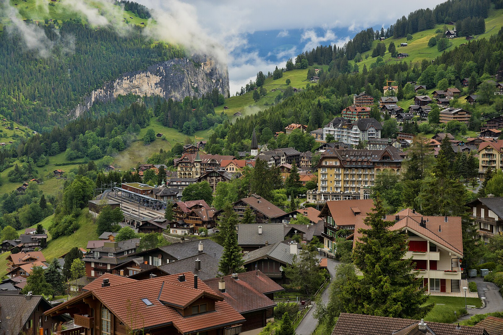
A car-free sanctuary perched on a sunny shelf, defined by its Belle Époque hotels and the thundering speed of the Lauberhorn run.
Highlights
- Car-free streets
- Belle Époque architecture
- Lauberhorn downhill race
- Cog railway access
Key Facts
- Altitude: 1282m
- Top lift: 2970m
- Ski pistes: 205km
- Ski lifts: 49
- Population: 1,300
- 4000m+ peaks nearby: 9
- Lakes nearby: 10
- MTB trails: 95.1km
- Mountain huts: 26
Ski Area
Zahrnuto v těchto sezonních permanentkách
Weather and 10-day forecast for Wengen
- Today: 10 to 16 °C, overcast, 3 h of sunshine
- Freezing level today: about 3742 m (3530 to 4000 m)
| Day | Min / max | Sky | Precipitation | Sunshine |
|---|---|---|---|---|
| čt 24. 9. | 10 / 16 °C | overcast | dry | 3 h sun |
| pá 25. 9. | 9 / 17 °C | clear sky | dry | 8 h sun |
| so 26. 9. | 12 / 19 °C | clear sky | dry | 12 h sun |
| ne 27. 9. | 13 / 20 °C | clear sky | dry | 12 h sun |
| po 28. 9. | 13 / 20 °C | clear sky | dry | 12 h sun |
| út 29. 9. | 15 / 23 °C | clear sky | dry | 12 h sun |
| st 30. 9. | 16 / 21 °C | partly cloudy | dry | 5 h sun |
| čt 1. 10. | 14 / 23 °C | rain showers | 5 mm rain | 11 h sun |
| pá 2. 10. | 12 / 14 °C | rain showers | 11 mm rain | 11 h sun |
| so 3. 10. | 10 / 17 °C | drizzle | 1 mm rain | 11 h sun |
Things to do in Wengen
Hikes nearby — Wengen (20)
20+ curated hiking trails around Wengen, sourced from OpenStreetMap and enriched with distance, elevation gain and difficulty.
-
ViaBerna Etappe 13
From the remote Saxeten valley, the route climbs through alpine pastures to the Bällenhöchst ridge, where a sweeping panorama opens over the Thunersee and Brienzersee alongside the Eiger, Mönch, and Jungfrau. The path then crosses wildlife reserves and steep mountain forest before dropping to Isenfluh, a village of traditional wooden houses perched directly opposite those same peaks.
-
ViaBerna Etappe 14
-
Via Alpina
Stage 68 of the Via Alpina threads between Grindelwald and Lauterbrunnen through the heart of the Bernese Oberland, where hikers move in the shadow of the Eiger and Jungfrau. The route passes through the quintessential car-free village of Wengen on its way across a landscape of Alpine pastures ringing with cowbells.
-
Eigertrail
The Eiger Trail traces the base of the Eiger's north face, delivering unobstructed views across the Lauterbrunnen Valley toward Mürren and down into Grindelwald. It runs as a point-to-point route between Eigergletscher and Kleine Scheidegg, mostly downhill, with the sheer rock wall of one of the Alps' most storied peaks looming directly overhead.
-
Via Alpina
Walking in the shadow of the Eiger and Jungfrau, this stage of the long-distance Via Alpina threads through the quintessential car-free village of Wengen on its point-to-point traverse of the Bernese Oberland. The route crosses Alpine pastures filled with the sound of cowbells, connecting Grindelwald to Lauterbrunnen across demanding mountain terrain.
-
Zweilütschinen - Isenfluh
-
Floschwald/Sausmatten - Grütschalp
-
Lauberhorn Trail
In summer, this point-to-point trail follows the famous Lauberhorn World Cup downhill ski race route from the start hut to Wengen, passing information boards along the way. The path unfolds beneath the Eiger, Mönch, and Jungfrau, connecting Wengen Allmend to Kleine Scheidegg through the Bernese Alps.
-
Lauterbrunnen - Schilthornbahn
markierter Wanderweg
-
Mountain View Trail
A point-to-point route running from Grütschalp to Allmendhubel, this trail delivers first-class panoramic views of the Bernese Alps' 4000m peaks — the Eiger, and its neighbours — in one sustained sweep.
-
Lieselotte Weg
The Lieselotte Weg is a themed trail that begins at the mountain station of Männlichen and descends to Grindelwald, offering stunning views along the way.
-
Bällefurgge - Suls
-
Sousegg - Sattel
-
ViaBerna Etappe 15
-
ViaBerna Etappe 12
-
ViaBerna: Isenfluh - Schynige Platte
-
Via Alpina: Grindelwald Bhf. - Lauterbrunnen
-
ViaBerna: Saxeten - Isenfluh
-
Eiger Trail
-
Panoramaweg Schynige Platte
Mountain biking near Wengen
- Alpine Bike - Etappe 12
- Mürren Bike
- Grütsch-Trail
- Eigertrail
- Pavillon trail
Getting to Wengen
Door-to-door travel times as used by the MR. ALPS ranking.
- Nearest airport: Bern Airport (BRN), 47 km away, about 3h09 by road
- Bern: 1h47 by train, 77 km
- Biel/Bienne: 2h22 by train, 109 km
- Luzern: 2h40 by train, 90 km
- Zürich: 2h44 by train, 194 km
- Basel: 2h54 by train, 177 km
- Lausanne: 3h06 by train, 173 km
Where to stay in Wengen
200 places to stay for a night on 2026-09-25, from 252 EUR per night, median 608 EUR. Prices are direct with hotels and destinations, compared live on the Wengen page.