Tannerfeld – Bayrischzell
Živá webkamera

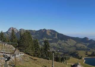
Otevřené vleky: 0%
Sněhová zpráva
- Posledních 24h: 0 cm
- Posledních 72h: 0 cm
- Posledních 7 dní: 0 cm
- Posledních 7 dní: Údolí 0cm · Střední část 0cm · Vrchol 0cm
- Sezónní úhrn: 0 cm
Lyžařská střediska otevřená právě teď · Sněhová zpráva
About Tannerfeld – Bayrischzell
A quintessential Bavarian retreat where rustic folk traditions meet the gentle, sun-soaked slopes of the Wendelstein massif.
Highlights
- Traditional Alpine architecture
- Family-friendly terrain
- Authentic Bavarian charm
- Scenic cross-country trails
Key Facts
- Altitude: 811m
- Top lift: 815m
- Population: 1,691
- Lakes nearby: 21
- MTB trails: 452km
- Mountain huts: 21
Ski Area
Weather and 10-day forecast for Tannerfeld – Bayrischzell
- Today: 5 to 16 °C, clear sky, 10 h of sunshine
- Freezing level today: about 3313 m (2100 to 3980 m)
| Day | Min / max | Sky | Precipitation | Sunshine |
|---|---|---|---|---|
| pá 25. 9. | 5 / 16 °C | clear sky | dry | 10 h sun |
| so 26. 9. | 9 / 21 °C | clear sky | dry | 12 h sun |
| ne 27. 9. | 10 / 22 °C | clear sky | dry | 11 h sun |
| po 28. 9. | 14 / 24 °C | clear sky | dry | 8 h sun |
| út 29. 9. | 14 / 22 °C | clear sky | dry | 11 h sun |
| st 30. 9. | 12 / 20 °C | clear sky | dry | 9 h sun |
| čt 1. 10. | 10 / 17 °C | clear sky | dry | 8 h sun |
| pá 2. 10. | 11 / 14 °C | rain | 2 mm rain | 0 h sun |
| so 3. 10. | 12 / 20 °C | rain | 1 mm rain | 11 h sun |
| ne 4. 10. | 12 / 17 °C | drizzle | 1 mm rain | 11 h sun |
Things to do in Tannerfeld – Bayrischzell
Hikes nearby — Tannerfeld – Bayrischzell (20)
20+ curated hiking trails around Tannerfeld – Bayrischzell, sourced from OpenStreetMap and enriched with distance, elevation gain and difficulty.
-
Via Alpina Purple A52
Brünnsteinhaus - Rotwandhaus
-
Weitwanderweg Ursprungweg
This nearly 55-kilometre long-distance trail winds from Wörnsmühl near Fischbachau over the Ursprungpass and on to Thiersee in Austria, passing through meadows, forest, and alongside running water with the mountain world always in view. Along the way, an audio walk — accessible via the free Livi AR app — brings the history of the Ursprungpass to life through two characters, Elli and Theo.
-
Wanderweg 645 - Spitzingsee
Von Spitzingsee/Geitau auf die Rotwand
-
Wanderweg 596 - Bayrischzell
-
Wanderweg 646a
-
Wanderweg 658 - Brünnstein
Tatzelwurm - Rosengasse - Traithenkessel - Feldalmsattel - Nesseltal
-
Bayrischzeller Höhenweg
The trail winds in serpentines through forest above Bayrischzell before opening onto the sunny meadow hollow of the Neuhüttenalm, where the Ursprungtal drops nearly 500 metres below and the view stretches freely into the Tyrolean mountains. Cows still graze the remaining alms on the Seeberg's flanks, a landscape shaped by centuries of alpine farming — and, briefly, by Bavarian soldiers who kept watch here against Tyrolean Gebirgsschützen between 1806 and 1809.
-
Wanderweg 646 - Spitzingsee
-
Wanderweg 657 - Brünnstein
Stezka stoupá idylickými alpskými loukami kolem alm Baumoos, Seeon a Himmelmoos až k Brünnsteinhaus, odkud se panorama rozprostírá od Kaisergebirge po Centrální Alpy. Cestou se světlý vápenec Oberrhätkalk vrcholu — vzniklý v mělkém teplém moři před 200 miliony let — tyčí jako zkamenělý lodní příď nad mořem korun stromů a se štěstím můžete spatřit kamzíky toulající se po svazích v oddělených stádech.
-
Wanderweg 659 - Trainsjoch
The Trainsjoch sits on the border between Bavaria and Austria, its open, free-standing position making it an exceptional viewpoint — particularly toward the south into the Bavarian Alps. The route passes the Mariandlalm at around 1.200 m, an alpine hut with a sunny terrace, before the final approach steepens sharply just below the summit.
-
Wanderweg 653 - Brünnstein
Über die hintere Gießenbachklamm zur Himmelmoosalm, Seelacheralm zur Schneelahnerhütte (Nähe Tatzelwurm)
-
Wanderweg 652 - Brünnstein
Von Buchau, Wall oder Hocheck über das Brünnsteinhaus auf den Traithen und über Vogelsang nach Bayrischzell
-
Wanderweg 651 - Brünnstein
Stezka obchází Brünnstein — světlý vápencový vrchol z Oberrhätkalk, který jeden alpinista 19. století nazval nejkrásnější horskou formou v bavorském údolí Inn — a míjí almy Baumoos, Seeon a Himmelmoos, než dosáhne chaty Brünnsteinhaus pod vrcholem. Při troše štěstí mohou turisté spatřit kamzíky v okolním terénu, kde žije populace dvaceti až padesáti zvířat pocházejících od pěti švýcarských jedinců vypuštěných v roce 1963.
-
Wanderweg W7
-
Wanderweg 49 - Kiefersfelden
Mühlau, Brünnstein, Steilenalm, Unterberg-Alm, Oberaudorfer-Alm, Gießenbachtal, Breitenau, Kiefersfelden
-
Wanderweg 647 - Valepp
-
Alpiner Premiumwanderweg Spitzing Panorama
-
BF4 - Hochgenuss
-
BF11 - Jetzad werds zach
Nordic Walking - Bad Feilnbach
-
BF6 - Über Stock und Stein
Mountain biking near Tannerfeld – Bayrischzell
- Zur Lacheralm und zurück
- Zur Walleralm und zurück
- Zur Niederhofer-Alm und zurück
Getting to Tannerfeld – Bayrischzell
Door-to-door travel times as used by the MR. ALPS ranking.
- Nearest airport: Salzburg Airport (SZG), 75 km away, about 1h21 by road
- München: 1h07 by car, 79 km
- Innsbruck: 1h27 by car, 102 km
- Nürnberg: 2h36 by car, 247 km
- Bolzano - Bozen: 2h52 by car, 217 km
- Stuttgart: 3h19 by car, 312 km
- Trento: 3h23 by car, 273 km
Where to stay in Tannerfeld – Bayrischzell
122 places to stay for a night on 2026-10-02, from 135 EUR per night, median 327 EUR. Prices are direct with hotels and destinations, compared live on the Tannerfeld – Bayrischzell page.